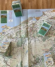
West Moray, Nairn & Dava Map
- In stock, ready to ship
- Backordered, shipping soon
Trailmaps West Moray, Nairn & Dava Map
The West Moray, Nairn and Dava map covers a vast area of over 1800 sq km from Grantown and Tomatin north to the Moray Firth coast. The map extends from the Spey valley in the east to Tomatin and the A9 in the west. It covers the wild landscapes of Dava Moor and huge forested areas such as Altyre, Darnaway and Cawdor . Adjacent to the coast is the Laich of Moray with its many sand dune forests and rich arable land.

The map is printed on waterproof paper at a size of 62 x 32 cm and folded into a compact size of 18 x 8 cm. Most importantly it shows and grades all the known cycling trails and they are clearly annotated with hazards such as locked gates.

* Trails graded for MTB & gravel bikes
* 4 grades of single and double track
* Grantown, Forres, Nairn, Slochd, Tomatin and Cawdor
* The Dava Way, Lochindorb, Culbin, Darnaway and Roseisle
* Rothes, Paul's Hill, Tom na Clach, Moy, Logie & Berry Burn Wind Farms
* The Moray Coast Trail to Lossiemouth.
* Speyside Way from Grantown to Knockando
* Sustrans Route 1 & 7

The map covers an huge area in Moray, Nairn and Dava Moor, loocated on the edge on the Moray Firth. Moray and Nairn have excellent transport links including regular bus and train services from both Aberdeen and Inverness.


