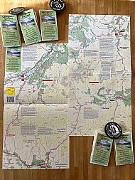
Cairngorm Carousel Map
- In stock, ready to ship
- Backordered, shipping soon
Stage 1 - Blair Atholl to Kingussie
Stage 2 - Kingussie to Tomintoul
Stage 3 - Tomintoul to Braemar
Stage 4 - Braemar to Blair Atholl
The Cairngorms Carousel is an off-road hiking or mountain biking route around Britain’s largest and most remote mountain range. The route is described in stages that any fit and moderately capable mountain biker could complete in 4 days. The Cairngorms Carousel is not an official waymarked path and it runs through remote and rugged terrain. The route for each day starts and finishes in villages with good accommodation, food and amenities. Hikers cover the ground more slowly and will need to wild camp between villages. The best way to complete the route is on a good quality mountain bike, travelling light with overnight stops in hostels.
The circuit is split into 4 stages.
Stage 1 covers the route from Blair Atholl in Highland Perthshire, through Glen Tromie to Kingussie and Strathspey.

Stage 2 shows Strathspey and describes the route from Kingussie through Glenmore to Tomintoul. Those with some spare time could spend a complete day in Strathspey or Tomintoul to experience some of the best mountain biking in Scotland. Tomintoul lies on the north east edge of the Cairngorms National Park and is the furthest point from the start.

Stage 3 takes a route south from Tomintoul through Glen Avon and Glen Builg before climbing to the highest point on the circuit. This is followed by an awesome ride to Royal Deeside and the picturesque village of Braemar.

Stage 4 runs through the southeast corner of The Cairngorms before heading south through fantastic scenery, past The Falls of Tarf to Glen Tilt and Blair Atholl.

Circular off-road route around The Cairngorms
200 km of magical Highland scenery
Highland Perthshire to Strathspey and Royal Deeside
Complete route for mountain biking or hiking
Magical trails through remote Highland Glens
Glen Garry, Glen Tromie, Glen Feshie, Glenmore
Glen Avon, Glen Builg, Glen Tilt
Route description and track grading on one large complete map
Printed in colour on waterproof paper
The map is annotated with notes at points where it is easy to go wrong and diverge from the recommended route. Reading online Carousel reports highlights that not many adventurers make it without some navigation error. Read the map carefully, particularly the notes where others have made mistakes. Concentrate and take care with the navigation, especially at these critical points.
Top Tip......
Before your adventure do some research - read some of the on-line Carousel reports. Also take a look at the Cairngorms Carousel facebook page https://www.facebook.com/CairngormsCarousel/
Reading this in list mode and going back to the early postings shows the route starting at Blair Atholl and taking it clockwise over 4 days. Please add your experience by making comments.
** IMPORTANT SAFETY INFORMATION **
From photographs and reports The Cairngorms Carousel may look idyllic. It certainly is, especially on a good day, but please remember that this is remote and potentially dangerous terrain. The weather can change in an instant and severe conditions are not uncommon.
 
|
Photos - Tomintoul - 1 day apart. Conditions can change very quickly
Prepare for your adventure carefully and do not take any risks. If the forecast is bad or the rivers are in spate do not hesitate to abandon your trip and come back at a more suitable time. Know your limits and act responsibly.


