

Royal Deeside Biking Map
- In stock, ready to ship
- Backordered, shipping soon
Trailmaps Royal Deeside Map in the Cairngorms National Park.
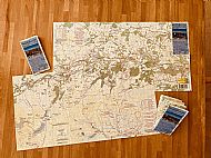
The Royal Deeside map covers 1,200 sq km of stunning Highland landscape from Balmoral to Banchory and Tarland to Glen Esk. The map is printed on showerproof pretex paper at a scale of 1:60,000 and shows all the known mountain bike and gravel bike trails in this rich cycling area.
It is printed at a size of 62 x 32 cm and folded into a compact size of 18 x 8 cm. The map grades into 4 categories of rideability and differentiates single and double track trails. There are clearly annotated suggested routes and hazards such as locked gates are shown.
Many thanks to Richard Watts (Cyclehighlands) and Andy Tivendale who both contributed their knowledge of the trails to produce the final version of the map. Finally many thanks to David Ritchie of a4 design and print for all his help and suggestions in the printing of the new map.
The map covers Royal Deeside and part of the Cairngorms National Park. It is perfect for both mountain biking, gravel biking and walking. This is the heart of Royal Deeside and there is something for everyone.
* Trails graded for MTB & gravel bikes
* 4 grades of single and double track
* Balmoral, Tarland, Scolty
* Glen Esk,Glen Tanar, Glen Muick
* Deeside Way from Banchory to Ballater
* Aboyne, Loch Kinord, Mt Keen
* The Fungle, Firmouth & Mounth Roads
* Single track MTB trails